


Neussarc chem des vielles pierres

taguette
User
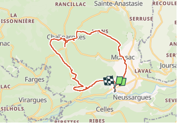

Length
19.3 km

Max alt
1096 m

Uphill gradient
436 m
Km-Effort
25 km

Min alt
815 m

Downhill gradient
438 m
Boucle
Yes
Creation date :
2024-08-20 09:02:43.616
Updated on :
2024-08-20 16:12:35.387
7h09
Difficulty : Very difficult

FREE GPS app for hiking
 SityTrail
IGN / Geographical institutes
SityTrail Plus
The world is yours!
About
Trail Walking of 19.3 km to be discovered at Auvergne-Rhône-Alpes, Cantal, Neussargues en Pinatelle. This trail is proposed by taguette.
Positioning
Country:
France
Region :
Auvergne-Rhône-Alpes
Department/Province :
Cantal
Municipality :
Neussargues en Pinatelle
Location:
Unknown
Start:(Dec)
Start:(UTM)
497341 ; 4997270 (31T) N.
Comments